
Roman control had collapsed in Britain by 410 AD and although this had a dramatic impact on parts of south-east England, life in north Devon probably continued much as before. The Celtic society that had built (and abandoned?) the hillforts presumably continued to flourish right through the Roman period and were relatively unaffected by its demise (1).
Christianity is thought to have been well established in Britain by c300 AD, well before the end of Roman rule. In north Devon there was an ecclesiastical community on Lundy by 480-500 AD and St Brannoc is said to have founded a chapel in Braunton in the 6th century. There are several other chapels in the region with a Celtic dedication (although most are from the 11th century), and there is place-name evidence for Celtic settlements at Charles and Wallsover (2).
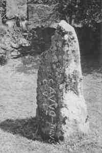
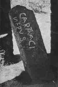
The principal remains from this period are several inscribed memorial stones; the Caratacus stone at Winsford Hill (left), which probably dates from about 600 AD; the Cavudus stone near Lynton (right), thought to be slightly later, and four inscribed stones on Lundy, thought to date from the 5th-7th century. There is said to have been an inscribed stone (now gone) at Holywell near Parracombe (3).
The popular legendary hero, Arthur, if he existed, came from this period, and was thought to have been a warlord or general, rather than a King. He was born towards the end of the 5th century and halted (for nearly two centuries) the Saxon invasion of the south-west at the battle of Mount Badon in c517. It is ironic that the greatest English hero was actually a Celt! Tintagel in Cornwall and Cadbury hillfort in South Devon are associated with Arthur and excavations there have revealed that both were occupied by royal households during the 6th century. Arthur may even have used the Great West Way to move between them, passing within a few miles of Hele (4).
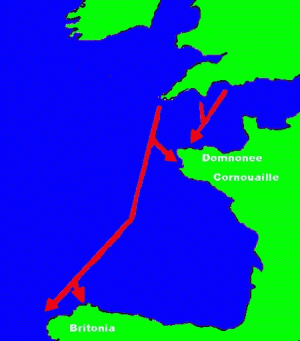
Despite Arthur’s success there seems to have been a migration from Devon and Cornwall to France towards the end of the 6th century (5). The true cause and extent of this is unknown; most likely they wanted to avoid Saxon rule, or were subject to famine, but there is also an (unlikely) tradition of a great disaster causing flooding around the south-west and a similar tradition exists in south Wales and Brittany (6).
 Despite the recent finds of Roman and Romano-British
metal-working in Brayford, very little is known of where and how local people
lived during these periods. Traditionally it is thought that most present-day
settlements were founded later, following the Saxon invasion of north Devon.
This is supported by the Celtic migrations to France and by local place-names,
which are overwhelmingly Old English in origin. But it is just as likely that
the Saxon's took over and renamed many existing settlements. It is pure
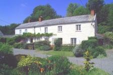
speculation, but Romano-British Hele (right) may not have looked so
very different from today (7).
Despite the recent finds of Roman and Romano-British
metal-working in Brayford, very little is known of where and how local people
lived during these periods. Traditionally it is thought that most present-day
settlements were founded later, following the Saxon invasion of north Devon.
This is supported by the Celtic migrations to France and by local place-names,
which are overwhelmingly Old English in origin. But it is just as likely that
the Saxon's took over and renamed many existing settlements. It is pure
speculation, but Romano-British Hele (right) may not have looked so
very different from today (7).
(1) End of Romans in Britain
"The Celtic kingdom of the Dumnonii was left undisturbed by the Romans throughout their long stay in Britain. After the Romans withdrew from Britain about the year 410 we do not know exactly what happened. But we can be fairly sure that in the west of England life must have gone on much as before" (Hoskins 1959 p 26)
In 409 Honorious wrote to the cities in Britain bidding them to look to their own defence against the barbarians. (Encyclopaedia Britannia 1978 Vol 19 p 542)
"It is generally assumed that the Roman retreat from Britain would have gone unnoticed by the ordinary people in the south-west (Todd 1987 The south west to AD 1000 Longman, London & New York p 236). Life on Exmoor and its hinterland, organised within petty territories, would have carried on." (Riley & Wilson-North 2001 p 85)
(2) Early & Celtic Christianity
"Celtic Christianity was that form of the Christianity held by much of the population of the British Isles from about the end of the fourth century, until some time after the year 1171..... Tradition holds that the faith was brought to the British Isles by Joseph of Arimathea and Aristobulus in A.D. 55 (some argue it was as early as A.D. 35) Modern scholarship rejects this, and places the introduction in the middle of the second century. Little is known of the first several centuries, however, Christianity was firmly established in Roman Britain by the time of the council of Arles (314) as two British bishops were in attendance" (Caedmon Greene, Introduction to Celtic Christianity, Orthodox Christianity in the British isles website 2001 [not available 2006])
Lundy
Lundy island was the home of small ecclesiastical community which came into being by AD 480--500. Lundy's absence in the later record is perhaps because it ceased to function as a religious house in the 7th century. Traces of two Celtic field systems survive on Lundy Island, one partly underlying the cemetery (University College London Database CISP sites, Beacon Hill, Lundy http://www.ucl.ac.uk/archaeology/cisp/database )
St Brannoc
Westcote, at the end of C16th, said that St Brannock came from Naples in 527 AD. Risdon in 1630, said that St Brannock lived in 300 AD. (Bowring 1931 p 110-111)
Braunton church is still dedicated to 6th century Welsh missionary St Brannoc or Brynach. Both William of Worcester and Leland tell us that St Brannoc was buried in Braunton church and now lies under the high alter (Hoskins 1954 p 220) A Welsh saint, St Brannock, landed on the shores of Barnstaple bay and founded a church at Braunton. There is no doubt that he is buried under the high altar of Braunton church, which is dedicated to him. (Hoskins 1959 p 40)
"On the north Devon coast lies Braunton, almost certainly the site recorded in a charter of Athelbald under the form Brannocminster (Finberg 1964a p 9). Here lie the relics of St Brannoc, and the English form of the name implies the existence of a community (Reaney 1935 1v)" (Pearce 1978a p 84)
"Braunton, which can be identified with considerable certainty as the Brannocmynster mentioned by 12th century historian, William of Malmesbury, and included in a 9th century charter, was one of the early Minster's or district churches founded in Devon from 6th century onwards. It has long had close associations with St Brannoc who, according to tradition, founded a chapel here. Like so many saints of the period, St Brannoc’s origins are obscure. There is a tradition that he was of Italian origin and has also been identified with the Welsh St ???, but is just as likely to be unique to Braunton." (Coulter 1993 p 25)
"The monastery of St. Brannock in Brandon claimed to have a charter showing it held land in the Hundred of Braunton and Shirwell in 650 AD. If this was true, there were British farmers in Shirwell itself before ever the Saxons got there. However, the first mention of St. Brannock we now have is in a document of the 9th century - 200 years later. Medieval monasteries were not above backdating their charters to give them a spurious air of authenticity. And the name 'Shirwell' is a Saxon one, meaning 'clear water', not British. St Brannoc, or Brynach, of Braunton was supposedly an Irish saint, who travelled to North Devon via Wales, and there are Irish memorial stones on the island of Lundy, just off the North Devon coast, to back up the story. In a period when it was quicker and easier to travel by sea than overland, North Devon would naturally have closer links with South Wales than South Devon. So St Brannoc's was probably originally a British-Irish monastery, and could well have had farms in Shirwell in the 7th century. By the time Saxons settled in Shirwell, they and the inhabitants would both have been Christian, so they may just have settled among the residents as 'incomers' still do today. Anglo-Saxons started arriving in Britain in the 5th century, or even earlier, but it was a long time before they began settling in the West of England. Devon only became part of the Anglo-Saxon kingdom of Wessex at the beginning of the 9th century. The process of settlement was probably quite gradual, so we need not imagine Shirwell being taken by force. Many North Devonian pace names have British elements like 'charles', 'wal' or 'weal' and 'coomb'. Loxhore, just down the road from Shirwell, is certainly a British name, meaning 'winding river'." (From Shirwell website 2001, see [2006] www.shirwell.org.uk)
Celtic dedications & settlements
There are Celtic church dedications at Berrynarbor SS560467, Braunton SS489371, Charles SS688330, Combe Martin SS586464, Culbone SS842482, Instow SS480310, Landkey SS590312, Parracombe SS675450, Trentishoe SS647486 (Grinsell 1970 p 210-211)
Celtic settlements at Charles SS687330, Wallover SS682384 (Grinsell 1970 p 210-211)
Celtic post-Roman settlements are believed to have been at Wallover south of Challacombe and at Charles, both Celtic place names. It is likely many hill-slope enclosures were also occupied at this period. (Grinsell 1970 p 102)
"A few of Exmoor's churches are dedicated to early Christian saints. This is a trend in the south-west, Wales and Brittany and commemorates the crossing of Irish, Welsh and Breton missionaries to and from the south-west peninsular in the 5th and 6th centuries (Grinsell 1970 p 103). Most of these dedications originate some 500 years later in the 11th century, the culmination of a hagiographical tradition and association between the great Abbey of Glastonbury and south Wales. On Exmoor such dedications occur at Culbone (to St Bueno); Brendon (to the 6th-century Irish saint St Brendan); Porlock (to St Dubricius; the Welsh saint who died c550 and was active in the spread of christianity in south Wales and the west); and Timberscombe (to St Petrock). While the evidence for most of these being 11th century is compelling, they do express yet another link between Exmoor and the rest of the south west and Wales." (Riley & Wilson-North 2001 p 85-86)
(3) Inscribed stones
Caratacus Stone
"The best known relic of the Dark Ages is undoubtedly the Caratacus stone [ss891336] on Winsford Hill. Its inscription shows it to be a memorial to some local magnate who claimed to be ‘Caarataci nepus’ a grandson or descendent of Caratacus (Caradoc), who may or may not have been the war-chief of the Silures in the early years of the Roman occupation. Any Briton would no doubt be proud of such descent, but the name of such a hero was probably popular for boys for centuries, just as that of Arthur is to this day. The inscription, including the misspelt nepus for nepos, shows characteristics, such as the joining of the T and A, which enable it to be dated to the end of the 5th or beginning of the 6th century...There is a farm, Croscombe, above Woody Bay, old spellings of which show that its name means Caradoc’s Combe. I would not venture to suggest any connection with the ancestor of the man whose memorial stands on Winsford Hill" (Whybrow 1970 p 42)
"Curiously the stone looks away from the ridgeway, perhaps towards the valley where the person to whom it is dedicated may have lived, perhaps the ridgeway has moved. It was mentioned as ‘Langeston’ in 1219 and 1279 perambulations of Exmoor forest. Its inscription was unknown until William Bidgood mentioned it to JLW Page in 1890 who went to see it and included it in his Exploration of Exmoor of 1890. After it was disturbed in 1923 by hooligans, Sir Thomas Dyke Acland had a protective shelter built over it. The translation generally accepted is CARATACI NEPUS, kinsman of Caratacus, but RAS McAlister thought it CARANACI NEPUS and references to St Carantoc in Somerset were assembled by AW Vivian-Neal" (Grinsell 1970 p 104) The picture of the stone from p 125 is shown above.
Cavadus Stone
"An inscribed stone of the Romano-British period has been discovered by the rev J F Chanter. The inscription has been deciphered by Mr Chanter and he states that it is a sculptural [sepulchral?] Inscription in bad Latin, probably in memory of a man named Cavudus or Cavucus, the son of Civilis, and may be 6-7th century, certainly between AD400-600. The stone is now used as a gatepost" (Ilfracombe Chronicle April 5th 1913 P5 C1)
"An inscribed memorial stone stands in the garden of Six Acre Farm, Lynton [ss701483]. Its original site was near the roadside between Woolhanger Cross and Caffyn’s Cross. Here the inscription reads ‘Cavudi filius Civili’ (the memorial) of Cavudus son of Civilus. The characteristic of this inscription is the horizontal rather than vertical positions of the letter I. This memorial is probably rather later than the Caratacus stone, perhaps about the middle of the C6th" (Wybrow 1970 p 42)
"This has since 1913 been in the garden of Six Acres farm. It was discovered by Rev J Chanter in 1913, when it was serving as a gatepost near Caffin Cross. It is about 6’6" long and the meaning is ‘the tomb of Cavudus, son of Civilus’". (Grinsell 1970 p 104-5) The picture of the stone shown above is from p 128.
"The majority of the inscriptions, however, run vertically down the stone, a change which probably reflects practicalities rather than epigraphy, although the Ogam inscriptions, which are required to be arranged in this fashion, may have exerted an influence. When the forms of the Roman capitals begins to degenerate the letters sprawl in unequal sizes and the final I is often recumbent instead of upright. At the same time, individual letters may be reversed, and letters may be ligatured. All these forms are illustrated on the stone from near Lynton (Chanter 1913) which reads vertically CAVVDI FILIUS CIVILI: here the D is reversed, the first and last three I’s are recumbent, and the two I’s in FILIUS have been ligatured with the F and L. Inscriptions with these forms should belong to the C6th." (Pearce 1978a p 24)
Lundy
There are four inscribed stones from Lundy near the chapel at the south. The best known is the Tigernus stone, which means 'lord' or 'landlord', the others inscribed Optimi, Resteuta and potit[i] (Grinsell 1970 p 105)
Beacon Hill, Lundy - a very early Christian burial ground has been identified, excavated in 1968 to find graves from 5th century onwards. 4 inscribed memorial stones from 5th to 7th Century. The inscriptions are Latin with some characteristics of Ogham script and read Tigerni (discovered 1905 but inscription not noticed until 1923 when Miss Amelia Heaven was buried), Potit, Resteuta (both with cross like symbols) & Timi (with circle with elongated stroke, like chi-rho, the very early Christian symbol) (Coulter 1993 p 48)
Parracombe
There may have been an inscribed stone near Holwell south of Parracombe. According to Rev Samuel Badcock, it was built into a bridge about 1775. The man who erected the bridge said ‘there were nearly 20 letters on it and they had an indenting between them, and were not of the common figure, for many persons, who examined them, pronounced them to be Greek.’ (Grinsell 1970 p 105)
(4) King Arthur
The Arthurian Legend, however wide-ranging its vagaries, is rooted in an Arthurian Fact. As the legend is unique, so the fact is unique. In essence, it is this. Britain, alone among the lands of the Roman Empire, achieved independence before the northern barbarians poured in, and put up a fight against them -- a very long, and at one stage a successful, fight...... our chief witness to this process, and almost our only native one, is an irritating monk named Gildas. Somewhere about 545, he wrote a diatribe against the rulers of Britain in his day.... Gildas makes nothing plain, except that it went on through victories and defeats for many years -- probably about forty -- and culminated in a British triumph at the 'siege of Mons Badonicus'. This battle brought a generation of peace and relative order, marred only by British feuds, not by heathen harassment. An early Welsh source, the Annales Cambriae, dates the 'battle of Badon' with a slight ambiguity in 516 or 518....The effects of the Arthurian Fact were profound; and they were lasting. When the conquest finally came, it was slow and piecemeal. Devon held out till 710, Cornwall till 825. Wales and parts of northwest England never succumbed to the Anglo-Saxons at all (Geoffry Ashe, The Quest for Arthur's Britain, Harper Collins: London, 1968, 1993).
King Arthur would have lived in the end of the fifth century to the beginning of the sixth century, with his birth most likely occurring around 470 A.D. and his death, as related in the folklore, in the year 539, at the Battle of Camlan. ... there was a classically educated, 'Romanized' minority that could read and write, as well as a literate monastic society. In the year 545, a monk named Gilda wrote an account of the decline of Roman authority in Britain and the events which followed. Most contemporary scholars and historians dismiss this source as unreliable and in many places entirely wrong, in any event, there is no mention of King Arthur in Gilda's writings.....Following the inclusion of Britain into the Roman Empire, the country managed to remain fairly autonomous. The educated members of the society adopted Christianity, brought into the country by the Romans, while the uneducated peasants remained pagan. Economically, the island exported grain, iron, coal, hides, hunting dogs, and slaves. Previous to the occupation by Rome, there had been raids by the Angels and the Saxons, but under the Empire, forts were erected to guard against these raiding forces and the would-be invaders were kept at bay. In 367 A.D., however, the Roman Empire began to dissolve. Britain, without this military backing, became defenceless almost overnight and the Angels, the Saxons, and the Jutes began to gain control of the countryside and cut off whole towns. .... In the ninth century, a member of the Welsh clergy, Nennius, is attributed with the work entitled, Historia Brittonum (edited in the 10th century by Mark the Hermit), a document that was discovered in the library of the Vatican Palace in Rome. In this work, Nennius speaks of Arthur not as a king but as a soldier: "Arthur fought against the Saxons alongside the kings of the Britons, but he himself was the leader in the battles (dux bellorum). The first battle was at the mouth of the river which is called Glein. The next four were on the banks of another river, which is called Dubglas and is in the region Linnuis...The twelfth was on Mount Badon, in which- on that one day-there fell in one onslaught of Arthur's, nine hundred and sixty men; and none slew them but he alone, and in all his battles he remained victor (Nennius 1819)....C. A. Raleigh Radford was asked by the British Ministry of works in 1930 to investigate the Arthurian history of the Tintagel site. His excavations went on intermittently for thirty tears, the most important aspect of his work, for this paper, being what he refers to as 'Site A' , which is approximately 150 feet north to south and about 60 feet from east to west. This site was covered with a number of structures that he divides into four periods, the first 450-700. Radford agreed with Jensen's earlier suggestion that Tintagel was the site of a Celtic monastery, during Period 1. One of the main reasons for this assessment was the presence of what he perceived to be a leacht.... however, he did not find any graves associated with this leacht, a normal accompaniment ....More recent interpretations of the Tintagel site suggest a very different function ... In 1981, O. J. Padel began a study of the Cornish background of the Tristian stories. ... discovered that Tintagel, in Cornish, pre-Norman folklore, was always referred to as a 'royal palace'. Padel suggested that this could account for the mass supply of imported pottery found at the site and further surmised that, "Tintagel was the (or a) dwelling of the rulers of Cornwall in the period of the imported pottery" (Padel 1984)....archaeologist Charles Thomas began re-evaluating the site and resorting and studying the pottery sherds that were uncovered by Radford. He first dismissed the leacht as 'atypical' and not very reliable in interpreting the site as a monastery and then suggested that the pottery was the only way to accurately date and interpret the Period I occupation (Thomas 1988). Lynette Olson, in her book, Early Monasteries in Cornwall (1989), is doubtful that Tintagel was the site of an early monastery, as well, an opinion is based on the absence of any associated funerary remains. In 1965, a few fragments of imported pottery, like those found at Tintagel, were discovered at Cadbury....formation of the Camelot Research Committee, members including C.A. Raleigh Radford, Geoffrey Ashe, and Phillip Rahtz, under the direction of Leslie Alcock. From July 15 to August 6, 1966, there was a trial excavation... Three sites, Site A, Site B, and Site C were identified .... They discovered several layers of habitation at each site, covering a large time span, from the Neolithic (3000 B.C.) to a occupation in the first millennium B.C. which produced mass amounts of bronzes and Bronze Age pottery. The pre-Roman Iron Age was marked by loom weights, weaving combs, and La Tane III brooches. This rich material culture continues until the Roman Conquest. The next layer contained burnt pottery shards, which could suggest a violent end to the settlement around 45 A.D. (Alcock and Ashe 1971). This is followed by a Roman Period occupation, marked by third and fourth century pottery. The next level of use...contained mass amounts of Tintagel class B pottery, suggesting a major occupation of the site during the dark age. ....The excavations at Cadbury continued throughout the summer of 1970 and the new information that was collected further supported the notion of a dark age, military stronghold. ..... What they discovered was that when the hill was re-occupied in the second half of the fifth century or slightly later, that they earlier defences were reconstructed and fortified. This refortification consisted of an unmortared stone wall, sixteen feet thick, with blocks of Roman masonry on to pf it, in addition to a surrounding earth bank, an internal drystone wall, and a gate tower with two entrances (Alcock 1968). Area postholes suggested other buildings and a small amount of Tintagel-like shards (A Short History of Arthurian Archaeology by Michelle L. Biehl, written for Archaeology of Europe, University of Minnesota, 1991 http://www.jammed.com/~mlb/arthur.html )
(5) Migrations to Brittany
Migrations from South-West England across the channel to Amorica, which became Brittany, reason unclear, local evidence is some names which mean ‘old farm’ or ‘old land’ - such as Yellaton - suggest that some early farms were abandoned (Hoskins 1954 p 40) The fields near Killacleave are called Yellands.
Procopius of Caesarea wrote a chapter about Britain in his history of the Justinian wars against the Goths in Italy. "It contains clear reference to the British migration which at this time was turning the peninsular of Amorica into Brittany - [footnote] the general tendency of the available evidence suggests very strongly that this migration took place in the first half of the C6th (W H Stevenson, EHR xiv pp44-5)" (Stenton 1955 p 4-5)
"One event stands out in this long, dark period and that is a large migration of people from Devon and Cornwall across the channel to Brittany. This probably took place in the C6th or C7th. It is thought to have been caused by years of plague and famine, which made life so difficult that the survivors crossed the channel to start a new life in a new country. This is why the ancient language of Brittany was so like the ancient language of Cornwall and Devon " (Hoskins 1959 p 26-27)
"Some 250 years elapsed between the end of Roman rule and the arrival of the English in Devon; and during that period, and especially in the first half of the 6th century, much of the Celtic population migrated back to Brittany. The remaining Britons of the Dumnonii were too few to offer serious resistance to the English advance when this at last came, and there was plenty of land which new settlers could take without the need to fight for it." (Sellman 1962 p 16)
"The sixth century development of Breton Dumnonee and Cornouaille must surely relate to the nomenclature of south-western Britain, in ways which have not yet been unravelled." (Pearce 1978a p 2)
"A striking aspect of the time, however, and one that might well have affected parts of the region quite considerably were the emigrations from Devon and Cornwall to Amorica (Brittany). These were so intense that the name 'Brittany', reflecting the British origin of so many of the inhabitants, originated then. The reasons for the movement of people is unclear. The most compelling historical event was the advance of the Anglo-Saxons into southern Britain. But this alone is too convenient to explain such a large movement of people out of Devon and Cornwall. It is more likely that several reasons caused the emigration, one of which might have been the extensive trading contacts already established between the regions. That is not to say that parts of Devon and Cornwall were deserted. We should imagine, rather, a drift of people away from the south-west causing a dip in the population level." (Riley & Wilson-North 2001 p 85)
(6) Sunken Kingdoms
There is a tradition of a sunken province of Dumnonia, Lyonnesse off Cornwall. The antiquary Camden asserted that Lands End ran to the west to include the Scilly Isles, a map published in Beccles Wilsons 1901 book Lost England, shows a territory with 80 miles of coastline including St Michael’s mount. William of Worcester said that St Michaels Mount was 5-6 miles from the sea, and Doomsday refers to St Michael’s as 30 times its current extent. "The ‘drowning’ of Mounts bay is an instance of a phenomenon visible all around the south-west promontory of Britain...There, the estuaries of rivers appear to be filled with water to a far greater height than they were at the period when they were formed. The estuaries of the Exe, Tamar, Fal and Dart all share this characteristic and submerged forests have been reported at many sites along the coast. In his Report on Cornwall, Sir Henry de la Beche remarked that "submarine forests are so common that it is difficult not to find traces of them in the district at the mouths of all the numerous valleys which open upon the sea and are in any manner silted up". "If we turn to the Bristol Channel," asserted the eminent geologist Sir Charles Lyell, "we find that both on the north and on the south side are numerous remains of submerged forests;...one of those at Porlock Bay ...extends far from land. There is good reason to believe that there was once a woodland tract uniting Somersetshire and Wales, through the middle of which the ancient Severn flowed" (Pennick 1987 p 63-65)
"In his survey of Devon, the antiquary Risdon wrote "That region which geographers account the first of all Britain, and shooteth out furthest to the west, was once reputed the fourth part of this island, and supposed to be a kingdom before the sea swallowed up the land between St Burian and the islands of Scilly" (Pennick 1987 p 66) the date of this loss is the 6th century (possibly with similar losses in Brittany and West Wales) he reckons 60’ contour would be enough to make Scilly's part of the mainland." (Pennick 1987 p 70) [The sea level is thought to have been approximately 20m lower than now around 6,000 BC, see the Mesolithic period]
(7) Romano-British Hele?
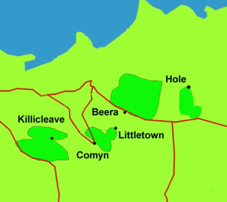
There are several approximately oval groups of fields around Hele, shown on the first Ordnance Survey map of 1889, that appear by their shape to predate the surrounding fields. There are two next to each other on the hilltops to the south-west of Hele, both elongated and lying along an east-west axis; one associated with Killacleave (about 20 acres) and the other with Bowden (about 35 acres). However, both may be topographic accidents since they enclose hill-tops and the enclosed land is steep and includes rough - not ideal for cultivation. There is another on the other side of the valley, associated with Comyn or Chambercombe (about 16 acres). There is a stream crossing nearby and it is possible that Cat Lane and Chambercombe Lane originated as a wet-weather route, used when the stream was flooded lower down in the valley. I have heard of an abandoned farm to the east of Comyn, and there is a level platform near the top of the fields, but the 1889 OS map marks a lime-kiln here. Above this is a small oval field associated with Littletown (about 3-5 acres) that by its small size, oval shape and raised elevation, is more likely to be the earlier settlement.
North of Beara/West Haggington, is a larger groups of fields, of about 80 acres, that could have supported perhaps 5 families.