
This is a list of links to pages that I think are the more interesting highlights of Hele's history. To return to this page use the back button on your browser.
Geology The sedimentary rocks of north Devon were formed about 400 million years ago, early in the development of vertebrates, in a shallow sea near the equator.
Palaeolithic Archdeacon Owen, who collaborated with Professor Leakey in Africa, found a Palaeolithic flint on Hillsborough in 1934. During the great Ice Ages Hele was many tens of kilometres from the sea.
Bronze Age The back lanes either side of Hele Valley are ancient ridgeway routes, which have probably been in use for 4,000 years. They join the only continuous ridgeway from England to Cornwall, probably used during the Neolithic period.
Hillsborough hillfort The massive Iron Age promontory fort on Hillsborough is one of the most impressive hillforts in north Devon. The 1889 Ordnance Survey map clearly shows the two rows of ramparts, each with an inturned entrance. An underground chamber was discovered and photographed in 1937, but filled in before it could be investigated. Hillsborough is said to be one of the few places in England where the sun can be seen rising from and setting into the sea.
Saxons Many local present-day settlements have Old English names. The tower of Holy Trinity church, Ilfracombe, was originally a Saxon lookout tower. Berrynarbor and Haggington were initially more important than Ilfracombe but were both marginalised by boundary changes in the 10th Century. The small Saxon Manor of Hela was probably at Little Town or near Comyn farm and in 1066 it was held by Edwy and paid 5 shillings a year in tax.
Normans In 1086 there were three families living at Hela, including that of a slave. The Manor had about 120 acres of arable land, 30 acres of pasture, 20 acres of forest and paid 10 shillings a year in tax.
Middle Ages Ilfracombe Manor was divided into two by 1160. The original Manor (including Hele) was granted to the Champernown family who probably built Chambercombe Manor. The first recorded gold mine in the country, discovered in 1262, may have been at Rillage Point. Ilfracombe Castle, shown in photographs of c1900, was probably built soon after 1418.
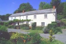
Tudor Helemyll was newly built in 1525 and Chambercombe Manor, occupied by Thomas Dyer, had about 30 acres of arable land and 120 acres pasture (the reverse of 5 centuries earlier). The principal crop at the time was hemp.
Civil War Ilfracombe Castle was attacked three times during the Civil War. The first two attacks were by Royalists in 1644, the first was repelled, but the castle surrendered to the second, a few weeks later, without a shot being fired. In 1646 the castle was retaken by Parliament and was closed in 1647. Lundy did not surrender until 1647, the last Royalist stronghold to capitulate.
Smuggling The legends of a skeleton hidden in a secret room at Chambercombe, and of a smuggler's tunnel to the beach, are probably no more than that. But eye-witness accounts suggest that there were smuggler's at Chambercombe in the 1850's. In 1831 a smuggling vessel, the Lively, was seized off Lundy after being reported by a party of fishing vessels from Ilfracombe, giving rise to the expression 'Combe Sharks'.
Lime Burning There were lime-kilns on Hele Beach, Larkstone Beach, Rillage Point, Chambercombe Lane (of which only Larkstone remains), and at Comyn, Hole and Beera farms. There is evidence of a succession of three kilns beside Hele Beach and the kilns at Rillage were still in use in the 1890's.
Turnpikes The main road through Hele, from Ilfracombe to Combe Martin, was built by one of the last Turnpike Trust's, granted in 1865. The road opened in 1868. A photograph shows the toll-gate in Hele, removed in 1888.
Volunteers The Ilfracombe Artillery Volunteers, founded in 1875 by Captain Simmonds, maintained a gun battery at Beacon Point until 1908, when they became part of the Territorials. The guns are said to have been buried around 1914 to prevent Ilfracombe from being classed as a 'fortified town' and were blown up during WW2.
Victorian Prints from the 1850's show Hele as a rural idyll. The village had expanded towards the sea and by 1841 there were 30 people living just in Hele Close (now Beach Road). In the 1890's, Hele Bay Estate was bought by the Ilfracombe Gas Company and in 1898 the principal farm of the Estate, later to become the site of the new gas works, was burnt down.
Edwardian Hele Bay changed dramatically between 1903-6, with many developments including a new Golf Course, new gas works, a new main sewer and Beach Road, Beach Terrace, the sea wall with coal store and office, a builders store....
Shipwrecks The hull of a torpedo gun-boat, probably the HMS Gossamer, dumped at Samson's Cove in 1920, and the keel of the Sarah Jane, wrecked off Beacon Point in 1924, can still be seen on the foreshore.